Soil & Nutrient Network – Case Study: East Balhalgardy, Aberdeenshire
4 February 2018Introduction to Balhalgardy
East Balhalgardy and the nearby unit of Auchencleith, farmed by brothers Bill and Alan Maitland, is a predominantly arable farm extending to 216 hectares on the outskirts of Inverurie, Aberdeenshire. The cropping enterprise includes spring barley and winter wheat, spring and winter oats and winter oilseed rape, while 22 hectares of permanent grassland supports a small suckler herd of 26 cows.
The majority of the farm lies on alluvial soil or brown forest soil of the Insch soil series. There are a few small areas subject to gleying and there is a small area of basin peat at Auchencleith that supports wetland habitat. Under the Land Capability for Agriculture system most of the farm is classified as 3.1 land with small areas of 3.2 and 4.2 land, particularly in wetter, low-lying areas, which includes part of the flood-plain of the River Urie. The whole farm lies within a Nitrate Vulnerable Zone and is in the River Don catchment, which has recently been designated a priority catchment by SEPA.
Soil Structure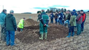
The Maitlands have used minimum tillage across the farm for several years, using a Claydon drill. At the first nutrient network meeting in February 2017, SAC Consulting’s Gavin Elrick examined the soil structure in a deep soil pit.
Although there was a hint of a compaction layer quite deep in the soil (probably as a result of many years of machinery travelling over the field), the top 50cm of soil, which is most important for root development, showed a good structure for growing crops.
Using the Visual Evaluation of Soil Structure (VESS) guide, the deep topsoil scored 1-2, being friable and at worst, breaking into small, rounded aggregates very easily. There was therefore no need to take action to improve the structure. of the soil.
GPS Soil Analysis
East Balhalgardy uses SOYL Precision Farming to carry out GPS soil conductivity testing in order to set variable seed rates for crop establishment. We were interested to look at the benefits of GPS soil mapping for nutrients and pH, compared with traditional analysis. In one large (27ha) field we carried out traditional routine soil analysis on a sample from each of three sections of the field, collecting an aggregated sample from 20 points along a zigzag path within each block. We then asked SOYL Precision Farming to carry out GPS soil analysis on the same field, using their standard sampling rate of 1 sample per hectare.
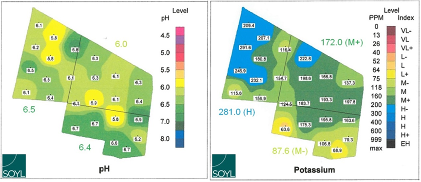
GPS maps of pH (left) and K (right) in a 27ha field with results of traditional soil sampling shown around the edge for each of three subdivisions of the field
Maps of pH and Potassium levels are shown above. Although there was broad agreement in the general pattern and values produced by both methods, the GPS sampling showed greater variability within the field. For pH, the traditional sampling method with three blocks showed a range of 6.0 to 6.5 while the GPS sampling showed a range of 5.8 to 6.9. For potash, the traditional method showed a range of 87.6 (M-) to 281.0 (H) while the GPS sampling showed a range of 63.6 (L) to 291.6 (H).
Maintaining Soil Phosphorus
The concept of soil phosphorus sorption capacity (PSC) is not well known among farmers, but SAC Consulting’s soil specialist, Dr. Alex Sinclair, was keen to draw attention to the subject, which is highly relevant to East Balhalgardy. The concept, explained in detail in SRUC Technical Note 668, is that different soils vary in their capacity to bind with phosphorus from fertiliser applications, which makes the nutrient temporarily unavailable to the growing crop. Soils can be classified on a scale of 1 (low) to 3 (high) for PSC and unfortunately the Insch soil series which predominates at East Balhalgardy is one of those classified as PSC 3.
To allow for the fact that phosphorus binds more effectively to this soil, the target phosphorus status to ensure that sufficient soluble phosphorus is available to the crop must be higher than for PSC 1 and 2 soils. While farmers should aim to maintain M- status (4.5-9.4mg P/l) on PSC 1 and 2 soils, they should aim for M+ status (9.5-13.4mg p/l) on PSC 3 soils. Building up from M- to M+ on PSC 3 soils would require an additional 20kg P205/ha/year, over and above the maintenance allowance for crop offtake.
Key Findings
- Minimum tillage can help to maintain soil structure on arable farms
- Download your copy of the Valuing Your Soils booklet to learn more about VESS & assessing your soil structure
- Find out the phosphorus sorption capacity (PSC) of your soil to ensure optimum application rates for phosphorus fertiliser
- Consider GPS soil sampling to show variability within your fields and to potentially reduce your lime bill
For more information on the Soil and nutrient Network see Farming & Water Scotland
For dates of SNN events, find us on Facebook or follow us on Twitter @FASScot ![]()
![]()
Read the meeting notes from the first meeting of the Aberdeen SNN group at East Balhalgardy here.

![]()
![]()
- Valuing Your Soils – Practical Guidance for Scottish Farmers
- This brochure includes useful information about Scotland's agricultural soils and practical advice outlining the upfront financial savings and business benefits of better soil management and the efficient use of resources. Action and problem-specific 'field-sheets' are designed for busy farmers with limited time for reading.
- Topics: Climate Change, Soils, Water Management and Crops and Soils
- Visual Evaluation of Soil Structure (VESS) Score Chart
- This is a downloadable copy of the Visual Evaluation of Soil Structure (VESS) score chart for use in-field.
- Topics: Soils
- Practical Guide: Managing Soil Phosphorus
- This Practical Guide will help you manage the phosphorus in your soils. It will help you understand the risk of phosphorus pollution and how you can reduce bagged fertiliser costs in grassland by incorporating nitrogen fixing clover into your sward.
- Topics: Climate Change, Soils and Water Management
- Technical Note (TN656): Soil Information, Texture & Liming Recommendations
- • Web based access to information on your soils on your farm is described. • Soil texture classes of mineral soils are described and identified by hand texturing. • Liming recommendations for different soils and managements are tabulated.
- Topics: Soils
- Technical Note (TN668): Managing Soil Phosphorus
- Efficient soil P management is challenging due to the varying ability of soils to mediate and regulate plant available forms of P. Farmers and land managers in Scotland are now able to access farm level information about their soils making it possible to provide more accurate P management advice.
- Topics: Crops and Soils

Sign up to the FAS newsletter
Receive updates on news, events and publications from Scotland’s Farm Advisory Service